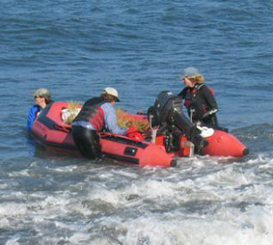
In March the MS211 class (Ecology of Marine Turtles, Birds and Mammals) climbed onto a small inflatable boat, pointed offshore, and ran a half mile obstacle course through rocks, waves, and seals to Año Nuevo Island.
This tiny boat (named Dragon Rojo!) carried us to the island. About an eight-minute boat ride though, so not bad. Photo from Oikonos.org.
Sedimentation is the process by which particles sink and accumulate on the seafloor. Layers upon layers of these settled materials tell the story of the oceans and climate from which they originated. Alterations to these sediments from compaction, bioturbation, and microbial respiration form sedimentary rocks through an action termed diagenesis. A better comprehension of diagenesis is needed to translate the sedimentary record into clues that help explain past events. To better understand these processes, students at MLML take the MS 274 “Advanced Topics in Oceanography” course. This class, taught by Dr. Ivano Aiello and Dr. Kenneth Coale, examines the factors that affect sedimentation and subsequent diagenesis in Monterey Bay.
A major driver of sedimentation is the ocean “biological pump.” This is the fixation of carbon by phytoplankton and the subsequent transport of plankton debris to depth. Over time, these materials undergo diagenesis as more sediments are deposited and compacted or consumed and disturbed by organisms. The process of diagenesis mimics many of the same processes as we observe in a compost pile, but occurs much slower.
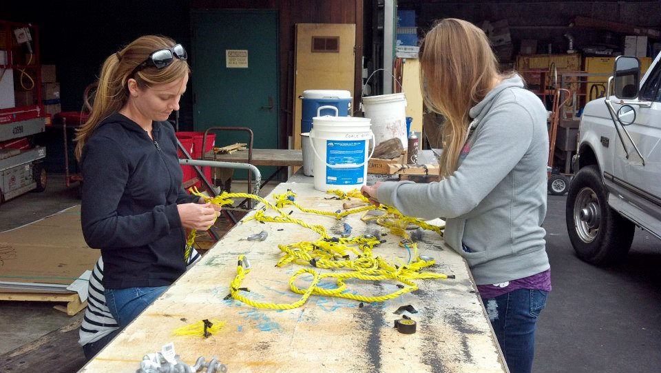
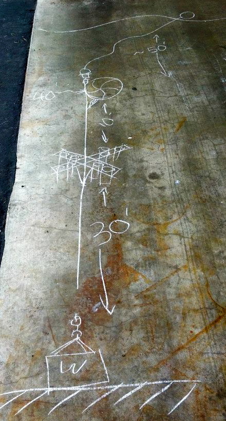
To study which organisms drive the biological pump in Monterey Bay, the MS 274 class constructed sediment traps. To build the array, we first mastered the technique of splicing rope together. This rope held our sediment traps to a mooring approximately 30 feet above the seafloor to ensure that the traps would be suspended in the water column. On top of the array, we fastened a surface float to aid in recovery. The purpose of the array was to catch fresh material that we could compare to materials in cores from the seafloor at the same location.
Emily Donham and Catherine Drake learning to splice rope to use for our sediment trap array. Photo by: Diane WyseDr. Kenneth Coale drew a schematic for our sediment array. Photo by: Diane Wyse
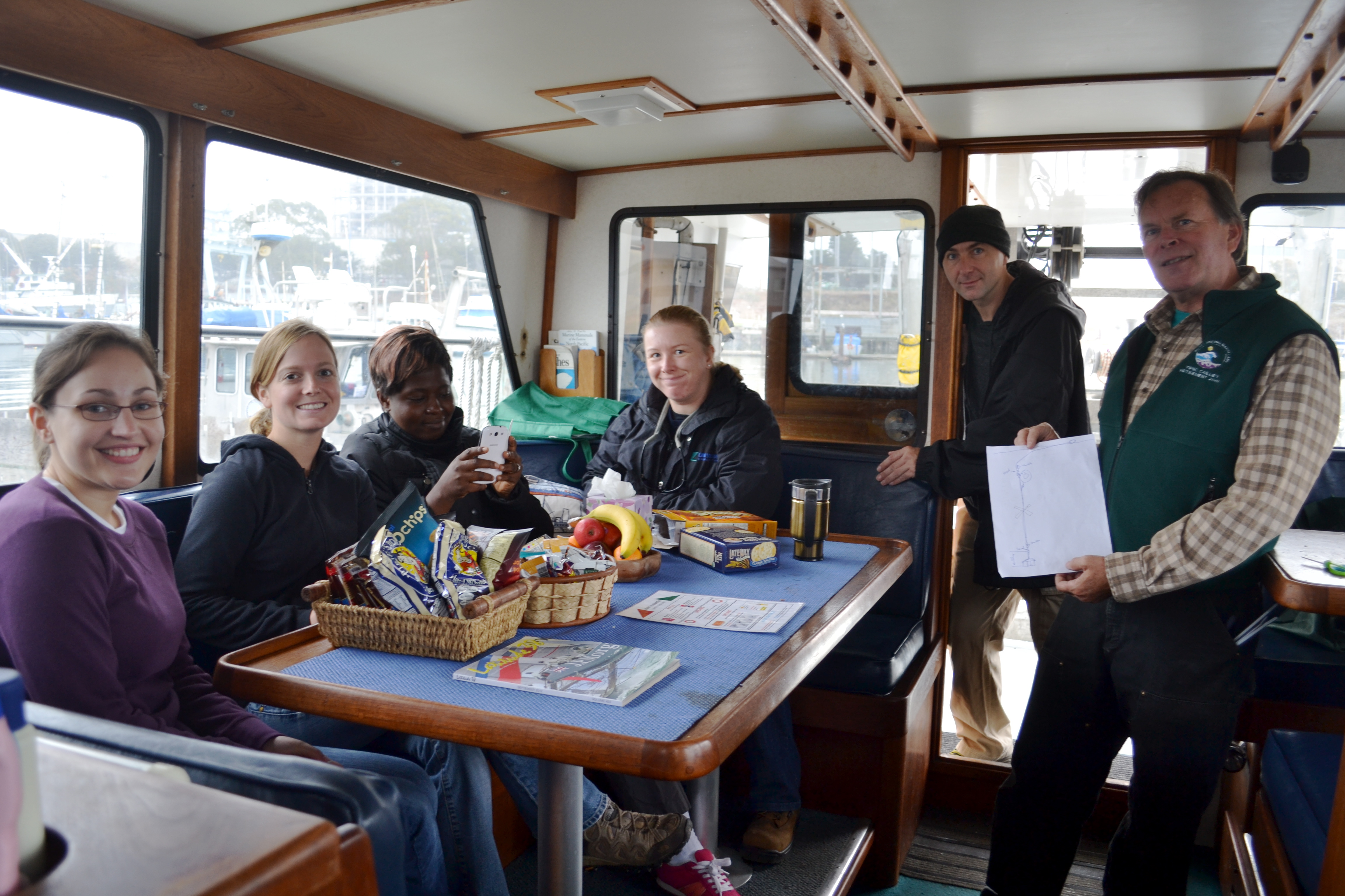
On September 24, 2012, we boarded the R/V John H. Martin and set a course for a location in Monterey Bay that was approximately 60 feet deep and deployed our sediment trap array. Then, two weeks later on October 8, 2012, we again set off aboard the R/V John H. Martin and collected the samples to begin our investigation into the process of sedimentation in the Monterey Bay.
The MS 274 class waits aboard the R/V John H. Martin to reach the sediment trap deployment site. Photo by: Catherine Drake
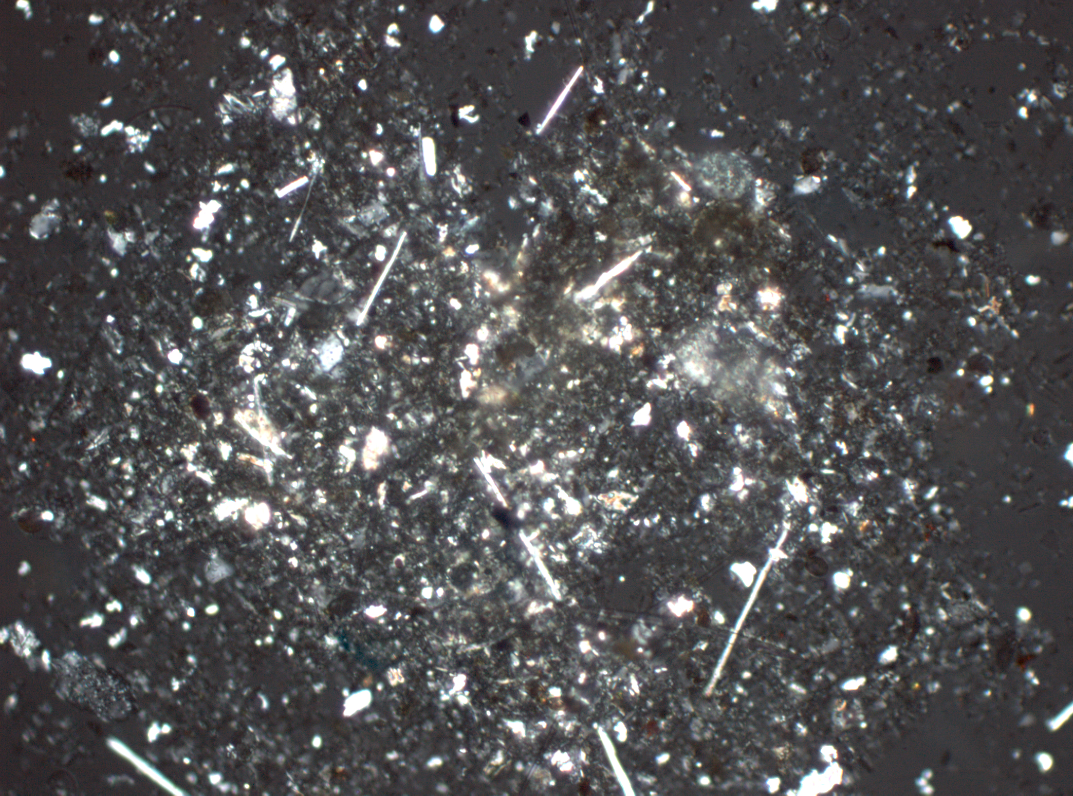
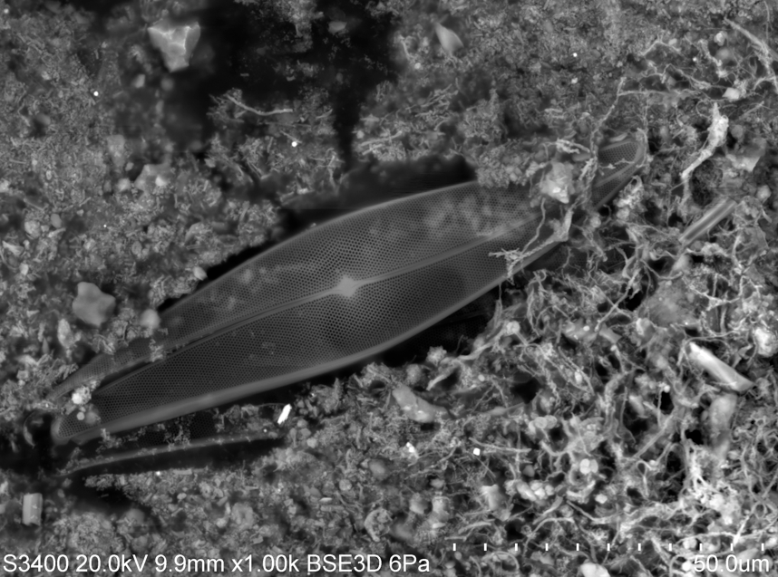
This involved many hours of sitting at multiple microscopes and quantifying the type of particles we saw; now, these microscopes that we used aren’t your average dissecting scope. Instead, to get a better depiction of the composition of each sample, we used two specialized types: petrographic and scanning electron microscopes. These specialized scopes gave us better resolution when trying to identify and quantify the lithogenic (of rock origin) and biogenic (of biological origin) particles in our samples.
This image is produced from a petrographic microscope, which uses polarized light to highlight the minerals in a sample. Photo by Catherine Drake.Scanning Electron Microscopy (SEM) shows a pennate diatom from a sample within the surface-sediment interval, or "fluffy" layer. Photo by: Catherine Drake.
Now remember that processes such as compaction, bioturbation, and respiration form sedimentary rocks through diagenesis. Due to a strong current system in Monterey Bay, we hypothesized that biogenic substances would be transported offshore and thus would not be present in a shallow, high energy, depositional environment, even though they are present in the water column. In contrast, it was hypothesized that lithogenic particles would be dense enough to deposit in a turbulent coastal environment.
We actually found that there was a higher percentage of lithogenics in both the sediment traps and the cores. For the two weeks that the sediment traps were deployed, dredging was occurring in the Moss Landing harbor, making the water very turbid. So, we suggest that this could be a possible explanation for the high percentage of minerals in the sediment trap sample. Overall, we learned that Monterey Bay, with its submarine canyon and turbulent waters, is a very unique system when observing the processes of sedimentation and early diagenesis!
By Heather Fulton-Bennett, Biological Oceanography Lab
The term cruise generally brings to mind tropical weather and luxurious surroundings, but scientific research cruises are much more about long hours of work and only a few brief moments to enjoy the view. As a new student in the Biological Oceanography Laboratory, I was simply excited to get out on the water.
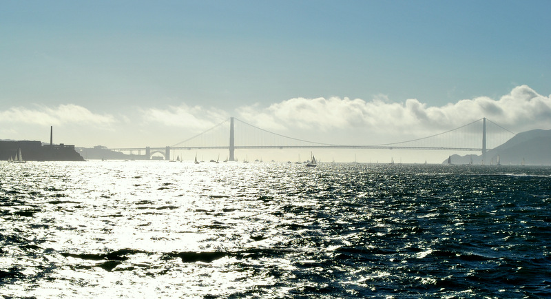
Our view of the San Francisco Bay and Golden Gate Bridge as we approached our anchorage for the afternoon
The Biological Oceanography Lab is part of a testing program for ballast water sterilization systems and utilizes the training vessel TS Golden Bear as a semi-mobile research station. With increasing concerns about the spread of invasive species through boating traffic, researchers are trying to minimize the potential for the viable organism to be transported in the ballast water of ships. State regulations focus on minimizing the number of live organisms present following treatment, and our lab is responsible for determining if treatment systems are effective by providing organism counts. Live organism counts are done by microscope on both the untreated and treated ballast water to compare the number of live organisms before and after the treatment. Current regulations require very low numbers of live organisms to be present in the water, so it is crucial to make sure the systems are effective.
For many graduate students at MLML, diving is an essential component to their thesis work, whether it involves collecting samples, obtaining data, or making observations about subtidal ecosystems. Students must be research dive certified in order to perform these science-related activities. Here at the lab, we have an excellent research diving program run by our research faculty member and Diving Safety Officer (DSO) Diana Steller. Through this program, students have the option of taking the course either during the fall semester or during a two-week intensive course in the summer.
DSO Diana Steller gives the ok after a tough beach entry at Big Creek. Photo by Maria Kyong.
Having gotten my open water certification earlier this spring, I was excited to take the summer research diving class. For the first week, we practiced a series of underwater skills and swim tests to ensure that we felt comfortable in the water. There are certain basic scientific skills that must be practiced and perfected to become certified in research diving. These skills include laying out a transect tape and taking observations along the tape. To master this, we all studied the local fish, invertebrates, and seaweeds to take surveys within the kelp bed for an organization called Reef Check.
I give the ok signal as I practice a Reef Check survey at Breakwater in Cannery Row. Photo by Scott Gabara.
The following week, we caravanned south to Big Creek State Marine Reserve; while there, we camped in the redwoods and dove consecutively for four days. We would wake up each morning bright and early, eat breakfast to fuel us for the first dive of the day, and then head to the beach. Diana and Assistant DSO Scott Gabara would brief us on the dives, we’d suit up and enter the water ready to take data. After our first dive, we’d sit on the beach with our lunches and warm up in the sun before heading out for our second dive. Once we completed our second dive, we would wade into the large creek (hence the campsite's namesake), wash off our gear and relax.
Diana Steller gives a brief on the dive site. Information in this meeting includes beach entry strategies, transect locations, and allowed depths and dive times. Photo by Maria Kyong.
The kelp canopy and sub-canopy are magnificent habitats at Big Creek. As I swam out to the location of each transect, I’d get entangled in giant kelp (Macrocystis pyrifera) and feather boa kelp (Egregia menziesii), and would use bull kelp (Nereocystis luetkeana) as an anchor when being pushed around by the swell. Once we descended, the seafloor was inundated with Pterogophora californica and Laminaria setchelii, so much so that I could not see the bedrock below. To obtain data for Reef Check, we placed the transect under the sub-canopy and crawled our way through the kelp to count stipes, look for inverts, and point our flashlights at unsuspecting rockfish.
Light can barely penetrate the dense canopy of Macrocystis pyrifera and Nereocystis luetkeana. Photo by Marina Kyong.
I noticed that during any dive, something can and will go wrong, especially when you have transect tapes, slates, compasses, dive computers connected to you as you maneuver underwater. The most important lesson I learned from Diana on this trip was that it’s how you react to these situations that determines your competence and confidence as a research diver. If you stay calm and remember to always breathe while your mask fills with water, you get caught in kelp, your datasheet falls off your slate, and the surge inverts you, then you are definitely ready for research diving!
Dive buddies pair up for one last picture after our last, and deepest, dive of the week. Photo by Maria Kyong.Our awesome summer research diving class! Photo by Maria Kyong.
This summer I hopped on a plane, flying 29 hours one way (via Paris — ooh la la) over a period of three days to spend nearly a month on the island of Madagascar working on my pilot study.
Madagascar, a former French colony until 1960, is the fourth largest island in the world. Don’t let it fool you. It looks so tiny next to Africa, but it has 44 percent more area than California, and boasts more than 4,800 km of coastline.
Rocky coastline in Madagascar. Photo by Angela Szesciorka.
Most of the country's export revenue comes from textiles, fish/shellfish, vanilla, and cloves. Newer sources of income include tourism, agriculture, and extracted materials (titanium ore, chromite, coal, iron, cobalt, copper and nickel). Madagascar provides half of the world's supply of sapphires! But with a GDP of around $20 billion, The Economist rated Madagascar as the worst economy in 2011. Most of Madagascar's inhabitants are subsistence livers, meaning they live off of what they can grow or catch.
Local fisherman spear hunting for crabs. Photo by Angela Szesciorka.
In 2011, I had the opportunity to participate in a California Collaborative Fisheries Research Program (CCFRP) fishing trip. When I received a message from Andrea Launer, CCFRP Volunteer Coordinator, this spring about the summer data collection schedule, I knew I wanted to go out again and be part of this amazing project.
With one of my classes starting on the first day of sampling, I wasn’t able to make the Monday, August 6th date but I was aboard F/V Caroline at Monterey’s Fisherman’s Wharf before sunrise on Tuesday with hot coffee in hand ready to do some angling. After a safety briefing by Captain Shorty we headed out along the Monterey coastline as Cannery row began to stir in the light of the pre-dawn sky. The sea was a bit rough and the wind waves made the trip out to the Point Lobos State Reserve a small adventure in and of itself.
Cheryl Barnes, CCFRP Field Coordinator and MLML graduate student, gave the anglers an amusing briefing about the specifics of the collection protocols of the catch and release program. In order for this work to be helpful in determining if the Marine Protected Areas (MPA) are effective in propagating the species within these areas since their inception in 2007, a variety of anglers were assigned different lures and/ or bait similar to fishing techniques used on guided recreational fishing trips from the area.
By the time Captain Shorty announced over the loud speaker to drop our lines in the water of the first research cell of the day, the rolling waves were already taking its toll on our balance and stomachs. The port side “fish feeding station” was busy early on but as the fog receded, we all got our sea legs and the fishing improved. The boat as a whole ended up catching and releasing a total of 176 fish from 14 different species, including a 84cm lingcod (Ophiodon elongates) caught by Chris L., fishing next to me. We must have been in some big fish because not too long after Chris’s lingcod, I hooked another giant fish, I estimated at over 100 cm (due to how hard it was to pull up) but after a perilous fight, the “Big One” got away as it neared the surface.
MLML grad student Katherine Schmidt measures a Lingcod. Photo courtesy of Starr Lab
While the anglers were pulling up their catch, the scientific staff was busy collecting the fish, measuring them, tagging some, and making sure they were returned to the bottom as soon as possible. I was thoroughly impressed how each staff member tried to make sure every fish was returned to their home with human stories to tell of their own. One sea lion, however, was happy to accept a free lingcod h’ordurve as it took a large bite out of an angler’s catch as it was reeled up. That lingcod, too, was returned to the ocean making a meal for the fish, crab, and sea stars that would finish the work of the sea lion. The seas were rough as we headed back in and even tossed a few of us out of our seats to the deck (Ouch!).
Among the coolest aspects of interning at the Monterey Bay Aquarium Research Institute (MBARI) are all of the opportunities for new and exciting experiences in marine science and engineering. On a beautiful Moss Landing summer day, fellow intern Samantha Peterson and I enjoyed one of those opportunities on a day cruise aboard MBARI’s R/V Zephyr. We steamed out of Moss Landing Harbor early in the morning, and after two hours of getting our sea legs and munching on snacks (to avoid sea sickness, for sure), we arrived at our first of two stops for the day. The cruise plan included a visit to the M2 mooring, a buoy deployed and maintained by MBARI scientists and engineers in partnership with the National Data Buoy Center (ID 46044), to download acoustic Doppler current profiler (ADCP) data and perform routine maintenance.
R/V Zephry from the M2 moored buoy. Photo: D. Wyse
The whole process of visiting and maintaining a mooring was really exciting to experience, especially as a student of physical oceanography. I got a kick out of the adventure inherent in maintaining oceanographic and meteorological instruments bobbing at the surface, moored 1000+ meters below on the seafloor. As I stood at the back of the Zephyr taking in the experience- the albatrosses gracefully landing to investigate our activities, the sea lion curiously poking it’s head up around the buoy, the scientists and technicians climbing onto the buoy from the side of the ship- I wondered what sort of training or security clearance one has the endure to work on the buoy. After pondering this aloud to my fellow intern, I inquired with the ship operator. His job was to carefully back the boat up to the buoy to transfer people and equipment, then to maintain a safe distance from the buoy while the technicians were working on it. As it turns out, it was surprisingly simple; I had to confirm with just about everyone on that day cruise that I am not sensitive to seasickness before getting the go-ahead to disembark the trusty Zephry and climb (well, pounce, really) aboard M2. I could see immediately what everyone was driving at once I was aboard the mooring. Because the platform is only about 10 ft in diameter, it is much easier to get tossed about with the swell. You feel much more in touch with the ocean on a smaller vessel. While ocean observers Mike Kelley and Jared Figurski downloaded the ADCP data, I climbed to the upper level to investigate the meteorological instruments. With my finely tuned CSI skills, I observed the evidence of seabird visitors on the solar panels and offered to clean off the droppings, you know, in the name of science. Surprisingly, they were more than happy to oblige that request, and I grabbed a cloth with seawater and scrubbed those panels squeaky clean.
The characteristic hexagonal pattern of the basalt columns form after the rock cools.
While on a beach down in Chile, South America the Moss Landing Marine Labs Global Systems class stumbled on a series of interesting rock features. The low silica rock of Chile flows easily and comes from molten lava, when it cools it contracts and forms. These cracks that form from cooling are roughly 6-sided, or hexagonal, and can form huge columns as seen at California’s Devils Postpile National Park. We took the liberty of testing the rock’s structural integrity while trying to climb these amazing columns. The columns seem man made, but knowing some basic geology helps to determine the origin, even when in another hemisphere from home.
You can tell these columns shifted after the time they were created by the way they tilt to the side.
Pretty easy to guess where this photo was taken with those landmark smokestacks in back! (photo: E. Loury)
When it comes to doing ichthyology field work, loading up on nets is only the first step – then you have to actually use them to catch fish! To study the sandy-bottom fishes in Elkhorn Slough, the MLML ichthyology class conducted a survey with a seine net. This net has a weighted bottom, so casting it wide then pulling the ends together like a drawstring corrals all the fish into a small area to collect and study them. What kind of fish did we catch? Stay tuned to find out!