
 By Jackie Lindsey, Vertebrate Ecology Lab

In the past few months, I have been asked more questions about oceanography than in the entirety of my career at Moss Landing. Inquiring minds want to know: what is this "El Niño storm" that will save us from the drought in California?
What is an El Niño?
We can look at El Niño events in the context of the ENSO, or El Niño Southern Oscillation. ENSO is a term for a "climate event" that is so large that it can affect global atmospheric circulation. ENSO fluctuates between three phases, which we refer to as El Niño, La Niña, and Neutral. How are they different? Let's talk about the Pacific Ocean.
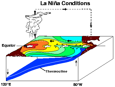
Under La Niña conditions, the Pacific Ocean sees below-average sea-surface temperatures. Strong trade winds blowing from east to west along the equator push surface water out of the way and allow deep, cold water to rise to the surface in the eastern Pacific. December 1988 in the below figure is a good example of La Niña conditions (think colder than average surface temperatures) across the Pacific.
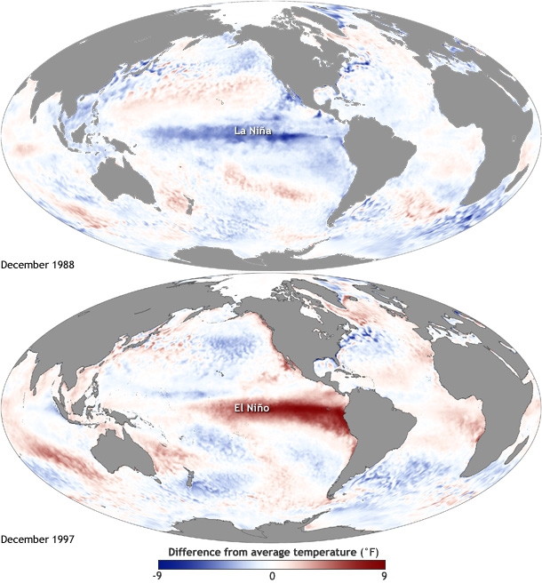
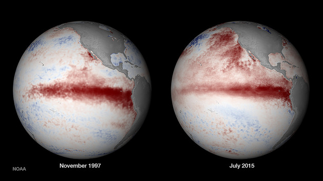
But check out the bottom image in this figure from December 1997: the strong east-to-west trade winds that blow the warm surface water out of the way for La Niña phases have lessened or even reversed. This allowed that warm water to pool on the eastern side of the Pacific Ocean. The water has sloshed back! The average sea-surface temperature is much higher than normal, and we call these conditions El Niño.
Notice how Peru is surrounded by warm water during an El Nino year? South American fishermen were some of the first to notice the ENSO phenomenon, because this warm water around Christmas time could do some serious damage to their normally very productive fisheries! They named this massive event "El Niño", in a seasonal reference to the "little boy" Christ child.
Enough about the ocean, what about the weather?
We cannot forget that what happens in the oceans is linked to what's happening in our atmosphere. Warm water in the ocean leads to rising air and tropical storms. La Niña phases usually have an increased amount of rainfall over Indonesia and decreased rainfall over the tropical Pacific.
El Niño years are typically the opposite, with increased rainfall over the tropical Pacific and decreased rainfall over Indonesia.
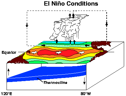
In addition to the atmospheric conditions, the above figures illustrate how water is pushed to the west in the La Niña phase and east in the El Niño phase. Keep thinking of sloshing water in a Pacific-Ocean-sized glass. The sloshing leads to warm or cold water at the surface and different atmospheric conditions as a result.
What does this mean for California?
I think you can see by now that El Niño is not a storm. It is not even a system of storms that will tumble through California, with enough water to save us from a series of drought years. It is much, much bigger than that. El Niño means changes in the ocean, which means changes in the atmosphere, which can affect atmospheric conditions and weather where YOU live.
Because we have been measuring and tracking the sloshing of the Pacific for several decades now, we can make some predictions about our atmosphere and our weather in an El Niño year like 2015. Scientists have seen the trade winds weakening and even sea-surface temperatures in the Pacific that are comparable to some of our strongest El Nino events, like November 1997.
Some climate variables may be different from previous years, but what scientists have seen this year has lead them to predict that we might get lucky (with the rain) if El Niño conditions continue to strengthen. In the past, El Niño has lead to wet winters in California. Storms in the Equatorial Pacific (remember that pool of warm water?) have the chance to be swept north by a branch of the jet stream. They might be carried far enough to the north that we will see rain in the northern parts of California. However, there are no perfect models, and this year might be different.
Will it help the drought?
Even in this lengthy piece, I have not described all of the factors affecting our winter weather. I simply cannot, and if you are curious, your research has just begun! You may have heard of "The Ridge" and "The Blob" (aren't meteorologists great at naming things?), which have affected rainfall in California. There's even a super-cool Pacific Decadal Oscillation that relates to ENSO, not to mention unknown effects of climate change on our global atmospheric patterns.
However our rainy season turns out, we should keep in mind that heavy rain on a dry landscape can mean dangers like flooding and landslides. California had trouble with this during our last strong El Niño of February 1998, so stay safe this winter!
You (and I) might want to do a little more reading:
ENSO climate.gov
Climate Patterns climate.gov
Rain in North America climate.gov
Keep the big picture in mind climate.gov
El Niño September update climate.gov
Ending the drought? news/opinion KCET