Castroville to the Coast
Field trip with State Senator John Laird to discuss a multi-benefit surface water enhancement project in collaboration with local growers.
Local resource managers will meet with state and federal leaders to discuss the conceptual multi-benefit watershed restoration project, “Castroville to the Coast”. This visionary multi-benefit water management project aims to increase climate resilience, decrease local flooding, improve water quality and wetland habitat while equally meeting the needs of community of Castroville, the participating farmers and the Monterey Bay National Marine Sanctuary. Partners agree that the Castroville to the Coast project can be a model for restoring the numerous watershed functions within the Salinas Valley we all rely on.
What: State Senator John Laird will be meeting with other state and federal representatives, local water resource stakeholders, members of the Castroville community, Monterey County Supervisor Phillips, and farmers for a field tour of two wetland areas around Castroville, one that has been restored and is improving water quality and one that is the next focus of the Greater Monterey Integrated Regional Water Management team.
When: October 18th
Where: The Castroville Slough wetland restoration project (east of Hwy 1, ½ mile north of Castroville) and then to the Tembladero Slough that has yet to be restored.
Why: Staff at the Water Board have recognized that the Moro Cojo Slough watershed currently achieves the nutrient limits outlined in Ag Order 4.0 for surface water protection, and therefore several Ag. Order 4.0 requirements may not apply to growers in this watershed. We now are focused on an exciting project in the adjacent Lower Salinas Valley to initiate similar projects to benefit water quality of the slough and Sanctuary as well as the community of Castroville and farmers of the Lower Salinas Valley.
Background: Voters in California have passed a number of Water Resource related bond acts to wisely invest in long term sustainable water resources including natural creek and wetland areas. Many of the Lands within the Salinas Valley that are most appropriate to restore to a more natural functioning watershed were reclaimed a century ago for farming, establishing the Salinas Valley as the Salad Bowl of the world. We therefore need to establish incentives for farmers to work with regional resource partners to reclaim priority lands along historical creeks and rivers for conservation and water quality improvements. A key incentive for farmers it to help reduce regulatory hurdles to farming.
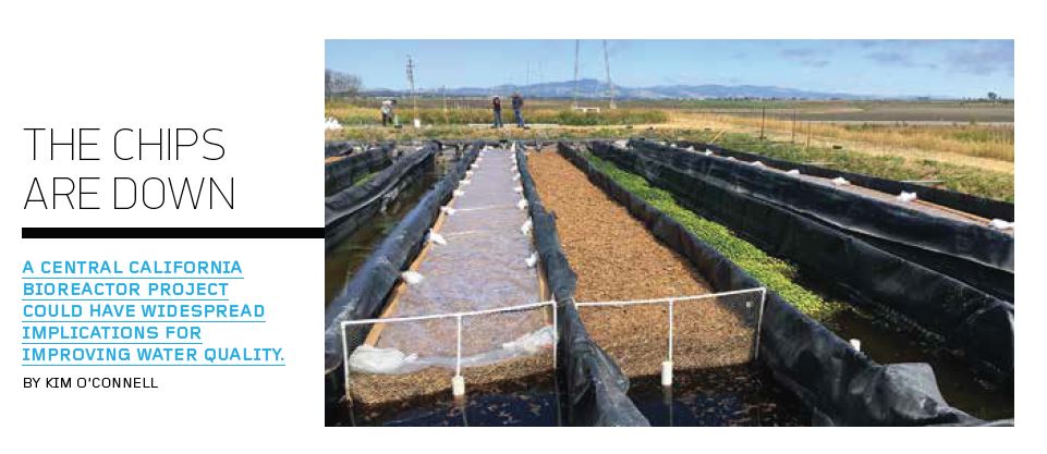
To address this challenge, the Regional Water Quality Control Board (Water Board) has reviewed a water quality data evaluation report provided by the Central Coast Wetlands Group (CCWG) and has determined that since 2016 nutrient concentrations in the Moro Cojo Slough (adjacent to Elkhorn Slough near Castroville) have been reduced sufficiently to meet the Moro Cojo Slough receiving water quality objective for nitrogen. The attainment of this environmental goal is the result of grower efforts to improve irrigation and nutrient application techniques within their fields and the construction of treatment wetlands and bioreactors by CCWG and Coastal Conservation and Research within the watershed intended to treat the remaining nitrogen fertilizer loads within communal drainages. (See Attachment 1 – Background, and our website for full data evaluation report)
More information: please visit the Central Coast Wetlands Group website (www.centralcoastwetlands.org) or contact Jenny Balmagia, Lower Salinas Valley Watershed Coordinator at jbalmagia@mlml.calstate.edu (831-771-4485).
Recognition of agriculture industry partners within the Moro Cojo Slough watershed
- Ocean Mist Farms
- Sea Mist Farms
- Springfield Farms
- Luis Scattini and Sons
- Top Flavor Farms
Landowners
- Hugo Tottino and family
- Ed Boutonnet and family
- Lou and Carol Calcagno
- Elio Rodoni and family
- Mike Scattini and family
More Background:
The Central Coast Wetlands Group at Moss Landing Marine Labs, Coastal Conservation and Research and the Elkhorn Slough Foundation have been working with landowners and state agencies since 1992 to restore wetland resources within the Moro Cojo Slough to improve habitat and water quality. These efforts have been guided by the Moro Cojo Slough Management and Enhancement Plan and have resulted in 100 acres of freshwater wetland habitat restored on nonproductive farmlands. These projects have been made possible by the landowners who have provided us access to these lands and various state grant programs that have provided design and construction funding (Coastal Conservancy, Central Coast Regional Water Quality Control Board, Ocean Protection Council, Wildlife Conservation Board).
Since 2004, six water quality enhancement projects have been constructed in the watershed. The Dolan property includes a sediment basin and treatment wetland adjacent to active farming areas that treat water prior to flowing into the upper portion of the Moro Cojo Slough (see Dolan in Figure 1). The Sea Mist treatment wetland (and the later added bioreactor) treat water flowing from 120 acres of farm land within the central Moro Cojo slough drainage (see Sea Mist in Figure 1). The Castroville Slough bioreactors and treatment wetland became operational in November 2016 and filter water draining 1000 acres of agriculture lands within the southern portion of the watershed (see Castroville in Figure 1)
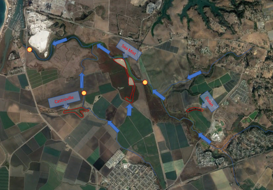
Figure 1. Locations of installed wetland treatment systems and habitat restoration areas (red) within the Moro Cojo watershed. Yellow dots and labels identify ambient water quality collection sites referenced within this document. Blue arrows depict flow direction through watershed to receiving water.
In May of 2020, the Central Coast Wetlands Group submitted a letter to the State Water Resources Control Board outlining the numerous water quality and wetland restoration projects that have been voluntarily implemented in the watershed by farmers and conservation organizations and the resulting incremental water quality improvements that have been documented over the past 20 years. Our findings suggest that since the construction of the Castroville Slough treatment wetland (completed in November 2016 and funded through a State Water Board grant program) the Total Inorganic Nitrogen concentrations (i.e. nitrate fertilizers) measured at the receiving water station near Highway 1 (309MOR) have consistently been below seasonal water quality thresholds recommended within the Lower Salinas Valley Nitrogen TMDL. Our letter documents the incremental improvements to receiving water quality achieved as each project within the watershed was installed (Table 1).
Table 1. Number and percent of water quality samples at the 309MOR with total inorganic nitrogen values that exceeded seasonal water quality thresholds (8mg/L wet season and 1.7 mg/L dry season total nitrogen as N) before and after each treatment project/wetland were constructed. No seasonal nitrogen exceedances have occurred since construction of the Castroville wetland in 2016.

