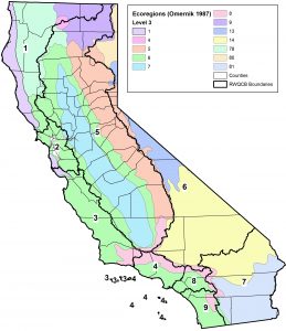
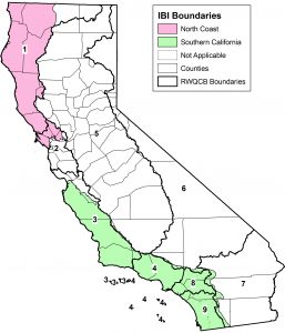
Zip files containing GIS shapefile layers are available for use in software such as ArcGIS to help populate fields in the Station Template that are associated with CalWater, Counties, Ecoregion, HBASA, and NHD. If you have any questions concerning these files, contact Cassandra Lamerdin or Marco Sigala.
Providing information from the different GIS layers increases the usability of data associated with stations for reporting and applications. To insure data integrity, MPSL-MLML prefers this information be populated by the agency that has created the station. If these resources are not available, contact your MPSL-MLML Liaison. We are working to provide a Station Locator tool to assist in populating this information.
CalWater
The purpose of CalWater 2.2.1 is to standardize the boundary delineation, coding, and naming of California watersheds by government agencies. CalWater also cross-references watershed codes implemented by the California Department of Water Resources (DWR), the California State Water Resources Control Board (SWRCB), and Regional Water Quality Control Boards (RWQCB), as well as Hydrologic Unit Codes (HUC) published by the U.S. Geological Survey (USGS) for California and the nation.
This zip file contains the files necessary to open CalWater 2.2.1 in ArcGIS to help populate specific fields in the Station Template. An Excel file is also available to help populate specific fields if the corresponding CalWater information is known.
Counties
This zip file contains the shapefiles for California counties.
Ecoregion Ecoregions denote areas within which ecosystems (and the type, quality, and quantity of environmental resources) are generally similar. These general purpose regions are critical for structuring and implementing ecosystem management strategies across federal agencies, state agencies, and nongovernmental organizations that are responsible for different types of resources within the same geographical areas (Omernik et al. 2000, McMahon et al. 2001).
This zip file contains the shapefiles for the EPA Ecoregion Level 3 classifications based on Omernik (1987). For stations outside California, the shapefiles are located at http://www.epa.gov/wed/pages/ecoregions/level_iii_iv.htm.
IBI (Index of Biological Integrity) This zip file contains the shapefiles delineating the North Coast and Southern California IBI boundaries. Stations sampled for bioassessment that fall within each boundary can have the corresponding IBI calculated. Stations that fall outside of the IBI boundary but within the same Ecoregion should use caution when interpreting results if the IBI calculation is performed.
As more IBI layers are added, we will make these maps available.
HBASA
The Hydrologic Basin information (hbasa2) was prepared by the California Department of Fish and Game (DFG) as a task within an inter-agency agreement for Geographic Information System (GIS) support to the California State Water Resources Control Board (SWRCB) Non-Point Source (NPS) Unit. Hbasa2 is a statewide version of the Teale GIS Technology Center (Teale) County Library data layer for hydrologic basins, called hbasa.
This zip file contains the shapefiles for the hbasa2 information needed to populate fields in the Station Template.
NHD Data Layers
SWAMP is requiring expanded National Hydrography Data Reach information. At a minimum, SWAMP would like the 24k fields populated; however preferably, attributes from all three layers will be populated (NHD 24k, NHD 100k, and NHD Plus).
NHD 24k (minimum)
NHD 100k (preferred)
NHD 100k Lakes and Reservoirs
Use this NHD file if the waterbody is a lake or reservoir with a polygon (area) shape.
NHD 100k Rivers
Use this NHD file if the waterbody is a blue-line feature such as a river, stream, or creek rather than a polygon shape such as a lake or reservoir.
NHD Plus (preferred)
Use this NHD file to obtain the NHDPlus_CatchmentComID. A User Guide on how to use the NHD Plus data layer is also available. The NHD Plus file was derived from http://www.horizon-systems.com/nhdplus/.

