Castroville Slough Treatment Wetland
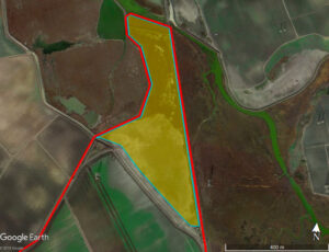
The Castroville Slough Treatment Wetland covers 18 acres of land in the Moro Cojo Slough watershed. The wetland is designed to reduce excess nutrients and other pollutants in water runoff, provide wildlife habitat, and help with flood control. Water is pumped into the wetland system from the Castroville Ditch which drains approximately 800 acres of farmland (predominantly artichokes and brussels sprouts), as well as a portion of the stormwater runoff from Castroville. Water is gravity fed through a 1.25 km sinuous channel that includes depressions and ponds with wetland plants and helpful bacteria that help to denitrify (or remove nitrogen pollutants from) agricultural water. The treated water then flows into the Castroville Slough about 200m downstream, and out to the Moro Cojo Slough before joining Old Salinas River and flowing the into the Monterey Bay. Researchers collect data from the wetland that help inform us of how best to improve water quality in the Castroville Slough and in other farming communities.
Documents: PG&E Constructed Treatment Wetland - Summary, PG&E Constructed Treatment Wetland - Designs
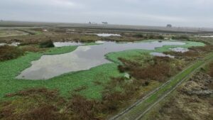
Sea Mist Treatment Wetland
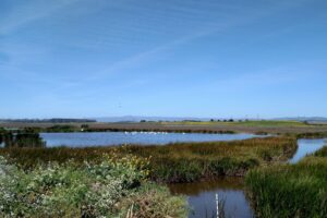
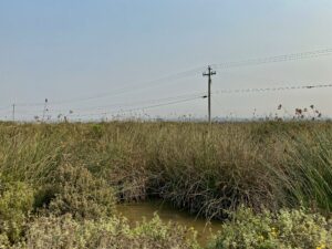
In 2006, CCWG built a treatment wetland at Sea Mist Farms to remove pollutants from agricultural runoff from adjacent farms. Three ponds and connecting channels totaling more than 21 acres of shallow freshwater habitat were created on the Sea Mist parcel, just downstream of the Union Pacific Railroad crossing. Water from approximately 150 acres of irrigated agriculture is directed to this restoration site for treatment and to provide valuable freshwater habitat. Water was also diverted from Castroville Slough to the Sea Mist parcel, flooding approximately 20 acres.
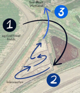
A bioreactor treatment system was added years later to further agricultural runoff. The bioreactor and treatment wetland work together in a system to improve water quality. The image below shows the flow of water from the agricultural fields, through the bioreactor, and out to the treatment wetland.
Documents: Implementation of the Moro Cojo Slough Management and Enhancement Plan: Restoration of the Core of the Watershed, Moro Cojo Slough Agricultural Management Practice and Treatment Project Summary
Molera Wetland
In 2005 the Molera Road Treatment Wetland was designed and constructed by researchers from CSUMB, MLML, and the Monterey RCD. Data collected at the wetland allows researchers to study how effectively constructed treatment wetlands reduce pollutant concentrations in agricultural water runoff. Constructed treatment wetlands are man-made versions of natural wetlands, designed to emphasize specific physical and biological characteristics to improve water treatment capacity.
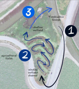
The image below shows the flow os water runoff through the treatment wetland. Agricultural water runoff is pumped from the Tembladero Slough into the Molera Road Treatment Wetland. Water then flows through the winding channel. Along the way, native plants and bacteria filter pollutants out of the water. Water exits the winding channel and flows through the shallow wetland, before returning to the Tembladero Slough. At each phase, the water becomes cleaner with much lower nutrient and pesticide concentrations! The Watershed Institute has ongoing studies of reduction rates and load characterization at this site.
Documents: Molera Road Treatment Wetland Summary, Agricultural Management Practices and Treatment Wetlands for Water Quality Improvement in Southern Monterey Bay Watersheds: Final Report
Dolan Conservation Easements and North and South Fingers Restoration
The Monterey County Agricultural Land Trust negotiated with the Dolan family to place habitat (122 acres) and agricultural (281 acres) conservation easements on parcels in the Moro Cojo watershed. The easement contributes to wetland restoration and conservation efforts in the Moro Cojo Watershed.
To enhance wetland and upland habitat resources within the lower Moro Cojo watershed, this project created areas for freshwater impoundments within the lower watershed between Moss Landing Road and Castroville Boulevard. The project also included the creation of buffers between wetlands and agricultural land uses, specifically in areas upstream of the Southern Pacific Railroad Tracks. Within the North and South finger project, sediment catchment basins were designed for both “fingers” of the wetland, and a raised road and culvert were created in the South finger. The North Finger treats about 120 acres of farm land, while the South Finger treats about 65 acres.
Sediment catchment basins are another form of water quality treatment systems that have been effective in treating agricultural runoff. The basins allow agricultural runoff to settle and denitrify. Nitrate concentrations at all three monitoring locations in the South Finger showed significant reduction (more then 50%) post construction of the sediment basin compared with pre-construction.
Documents: Dolan Border Moro Cojo Restoration Project

Hugo Tottino Wetland Restoration Site
In January 2017, the Central Coast Wetlands Group received funding from the Ocean Protection Council through Proposition 1, the Water Quality, Supply, and Infrastructure Improvement Act of 2014. The grant includes restoration of a 35-acre parcel in the lower Moro Cojo Slough, referred to as Hugo Tottino Wetland. The goal the restoration project is habitat enhancement, flood water retention, and water quality improvement. The water quality improvement will be accomplished through the use of water filtration, nutrient uptake, and denitrification performed by native vegetation. Construction and planting of the site is set to be completed in 2021.
Documents: Hugo Tottino Wetland Restoration, Construction, and Maintenance Plan