
Why MOBY measures color
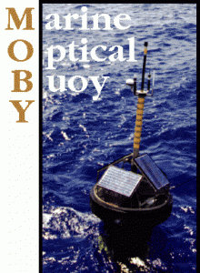 The Marine Optical Buoy (MOBY), a radiometric buoy stationed in the waters off Lanai, Hawaii, is the primary ocean observatory for vicarious calibration of satellite ocean color sensors. MOBY measures light near the sea surface (1, 5 and 9 meters) off Lanai from July 1997 to the present (over 10 years). The fundamental satellite measurement on which all ocean color products are derived is the water-leaving spectral radiance, Lwn. Water-leaving radiance from the ocean contributes only 10% (at most) of the radiance measured by a satellite sensor above the atmosphere (Gordon 1997), a 5% uncertainty in Lwn implies a 0.5% uncertainty in the above-atmosphere radiance measurements. This level of uncertainty can only be approached using “vicarious-calibration” methods. In practice, this means that the satellite radiance responsivity is adjusted to minimize the differences between an ensemble of satellite and in situ Lwn data matchups. Since late 1996, MOBY has been the primary basis for the on-orbit vicarious calibrations of all three US ocean color sensors and numerous international satellite sensors. The MOBY vicarious calibration of these sensors supports the international effort to develop a global, multi-year time series of consistently calibrated ocean color data products. Without MOBY’s vicarious calibration efforts, SeaWiFS derived values for Lwn would have been in error by 25% at 490nm and 75% at 412 nm [Franz et al. Applied Optics Vol. 46, No. 22, page 5068 – 5082 (2007)]