How do central California MPAs compare to one another?
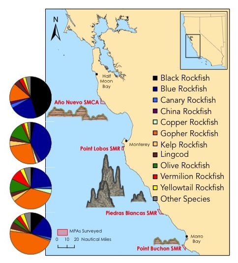
Año Nuevo and Point Buchon encompass low relief sedimentary rock, whereas Point Lobos and Piedras Blancas consist of high relief granitic rock. These contrasting habitats yield different species compositions throughout central California. Additionally, catch-per-unit-effort (CPUE) data show that fishes are caught in different proportions, depending upon species and area. Monitoring CPUE (a proxy for density) both within MPA boundaries and in suitable reference (REF) sites helps evaluate MPA effectiveness through time. Below are figures displaying the similaries and differences in species compositions among area (e.g., Año Nuevo) and between sites (i.e. MPA / REF). Please note that all MPAs were implemented in 2007, with the exception of Point Lobos State Marine Reserve, which was established in 1973 and expanded in 2007.

Figure 1. Map of CCFRP sampling area. Rock type, relief, and species composition is displayed for each area. The most commonly caught species used to make pie chartes are listed and color-coded to the right.

Figure 2. Species compositions for each color-coded area (left). Bray-Curtis similarity plot of CCFRP areas and sites (right). This figure shows that MPA and REF site pairs more closely represent one another than any other area, indicating appropriate site selection for this study. However, please note that the older part of the Point Lobos State Marine Reserve displays less similarity to its corresponding sites (i.e., newer MPA addition and REF sites). This is likely due to more than three additional decades of protection from fishing.

Figure 3. Species compositions, by area and site. Once again, you can see that MPA/REF pairs more closely represent one another than they do any other site at any other area.

