Check out the results of our latest beach surveys on the COAST website:
Author: Ivano Aiello
Learning from the 2016 El Niño
CSU's Council on Ocean Affairs, Science & Technology (COAST) has recently awarded Dr. Aiello with a 'rapid response' grant to study changes in beach morphology and sand budgets in Monterey Bay during the storm activity associated with the 2015 EL Niño.
Archives
In Monterey Bay, as well as along the whole west coast of the US, large storm events are the primary controlling factor over beach dynamics, and high-energy conditions are particularly intense during El Niño years. Large storms associated with EL Niño have dramatic effects on the coastal environments: they increase the sediment yield from rivers and accelerate the erosion of seacliffs and coastal dunes. Storm activity also produces along-shore currents that can move large volumes of sand parallel to the coastline (littoral transport, often referred to as a 'river of sand').
If along its way, the 'river of sand' is intercepted by obstacles like the head of a submarine canyon or a promontory, the sand can be deflected offshore and permanently transferred from the coastal environment to the deep seafloor where it is lost forever. This loss might affect the resilience of beach sediments which act as a primary coastal buffer to prevent or delay seacliff and beach erosion, some of the most compelling problems affecting California’s coastal environments.
Geologists call a portion of coastline that includes a source for sand (for instance a river's mouth), and a sink (for instance the head of a submarine canyon) a littoral cell.
The main sink for sand in the Monterey Bay is the head of the Monterey Canyon (C) which dissects the continental shelf and comes very close to shore right in front of Moss Landing Marine Lab. The segment of the beach between the mouth of the Salinas River (A), and Elkhorn Slough (B) is a small littoral cell (or sub-cell) which we call the Salinas sub-cell.
There are many littoral cells like the Salinas sub-cell along the California coastline: during 'normal' winter storm conditions the sand moves alongshore relatively slowly and not much sediment is lost from the littoral system. However, during El Niño condition sand circulation in the littoral cells occurs much faster. Not only is the 'river of sand' carrying larger volumes of sand but it can also flow in directions different from normal winter conditions because the swell, which typically comes from the northwest, is now coming from the west and the southwest.
Future predictions of raising sea level conditions combined with more frequent and larger storms and El Niño events require a better, more quantitative approach to understand sediment dynamics in littoral cells in relation to oceanography. Understanding sediment budgets in littoral cells during high-energy events and storm-dominated seasons provides essential planning tools for regional and coastal management.
To monitor changes in sand volume along the beaches of the Salinas sub-cell Dr. Aiello's Lab is using some of the most advanced mapping tools available in coastal geomorphologic studies. In early Fall 2015, before the beginning of the storm activity associated with the 2016 El Niño, we were able to coordinate a demonstration survey of the sub-cell's coastline using an unmanned autonomous vehicle (UAV) equipped with a very-high-resolution camera. Based on ground controls these images can be post-processed to produce high-resolution digital elevation models (DEMs) of the terrain as shown in the digital rendering of the Moss Landing Marine Lab building and surrounding property.
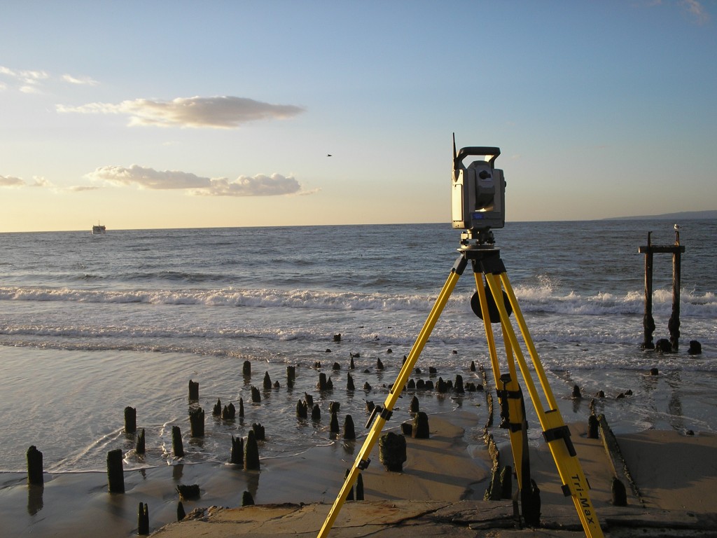
Our strategy is to combine the DEM baseline with 'ad hoc' high-resolution surveys of specific sections of the beach (the red, numbered lines in the first figure) before and after major storm events using a field-based survey equipment called a Terrestrial Laser Scanner or TLS. The TLS is a powerful, portable instrument for surveying rapidly and very accurately beaches, dunes, and many other coastal habitats including estuaries and the rocky intertidal.
At the end of this study we hope to gain a better, more quantitative understanding of the fate of beach sediments during El Niño conditions in Monterey Bay. What we can learn in the Monterey Bay can be also translated to other littoral cells in California and can be used to improve our ability to predict and possibly mitigate the effects of future climate and sea level changes.
If you have any questions feel free to contact Dr. Aiello.
Thank you for reading!
3D Scanning of Rocky Intertidal Ecosystems
This blog was originally posted in the OCEANSPACES website: enjoy!
Archives
Student Opportunities in the Geology Lab
Prospective students,
If you are interested in applying to the Geological Oceanography Lab at MLML, there are several research opportunities starting in Fall 2015. For some of these project I will be able to provide some support either in form of a stipend and/or tuition.
The following paragraphs describe potential research topics; however, to learn more about research opportunities feel free to contact me directly (iaiello@mlml.calstate.edu).
Ivano
Bar-built estuaries: bar dynamics and wetland topography (in collaboration with the CCWG)
California’s bar-built estuaries form where coastal streams and rivers are periodically closed off from exchanging waters with the ocean by the build up of a sand berm at their mouth. Changes in the timing of the berm buildup in relation to weather and oceanography have significant effects on the extent and quality of the estuarine habitats (e.g. lagoon, marshes). These habitats, which are essential for many marine and terrestrial species some of which are endangered, have been heavily modified by humans as consequence of deforestation and use of wetland areas for agricultural and urban purposes.
This project is a collaboration with the Central Coast Wetlands Group at Moss Landing Marine Laboratories (http://ccwg.mlml.calstate.edu).
Specific research topics include:
- Geomorphologic mapping/modeling with terrestrial laser scanners of marshes to establish inundation periodicity and vegetation community structure;
- Evaluation of bar formation dynamics using terrestrial laser scanning, beach camera analysis, and aerial photos
- Bar sediments analysis with laser particle sizing and provenance studies.
Understanding the behavior of ice sheets and sea ice in the Bering Sea region during the 40-K world (in collaboration with Christina Ravelo, UCSC)
This project is based on sediment cores collected by deep-sea drilling in the Bering Sea during IODP Expedition 323 (http://iodp.tamu.edu/scienceops/expeditions/bering_sea.html).
The time interval chosen for this study (~1.7 to ~1.2 Ma) is right before the Mid-Pleistocene Transition when global ice volume varied mainly at periodicities of 40 kyrs. This time interval offers straightforward examples of how ice sheet mass balance is affected by seasonal solar forcing.
Graduate theses will focus on measuring fluxes and sources of IRD (defined as >250µm lithogenous particles) and differentiating IRD derived from ice berg calving from lithogenous material coming from sea-ice. Goals are to better understand the role of sea ice in ice sheet growth/decay, and to determine IRD provenance to tie the IRD record to specific ice sheets. Analytical work will include bulk- and biogenic-free particle size measurements, SEM-based microtexture analyses, and QFL provenance analyses.
Archives
Welcome to MLML’s Geological Oceanography Lab!
Dear visitor,
MLML's Geological Oceanography website is slowly coming together and soon many of the links will be up and running.
If you are a student interested in joining our program at MLML you can contact Prof. Ivano Aiello directly at:
iaiello@mlml.calstate.edu
If you want to know more about what we are doing in the lab you can checkout two YouTube videos.
One is an interview with Ivano on marine sediments during an oceanographic cruise on the ship Joides Resolution in the Bering Sea:
The other video is an interview/documentary by Cassandra Brooks on the origin of oil:
http://www.youtube.com/watch?v=Ykfnz9yQ0I8
Thanks for visiting!
Ivano


