Welcome to the Computational Oceanography Lab!
The Computational Oceanography Lab was formed in 2023 as a new addition to the Moss Landing Marine Laboratories – how CoOL is that?! Here in the CoOL group, we use numerical ocean models, remote sensing observations, and in situ measurements to study the ocean and how it interacts with other components of the Earth System, such as the cryosphere and the biosphere. We are interested in a wide variety of different processes and locations in the global ocean.
Numerical Ocean Modeling
Numerical ocean models use physical equations of motion to simulate circulation and heat transport. The CoOL group primarily uses the MIT General Circulation Model (MITgcm) for our simulations as well as MITgcm-derived ocean state estimates provided by the Estimating the Circulation and Climate of the Ocean (ECCO) consortium.
Remote Sensing Observations
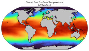
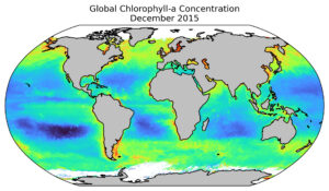
Remote sensing observations refer to measurements of the ocean from satellite or aircraft. Remote sensing observations use electromagnetic radiation such light from the sun, radio waves emitted by satellites, or even green-light lasers to infer information about processes in the ocean. There are a wide range of variables which can be observed from space including temperature, salinity, chlorophyll concentration, wind speed and direction, sea surface height, shallow water bathymetry and much more. Together, these observations enable us to learn about the entire ocean over years or even decades.
In Situ Measurements
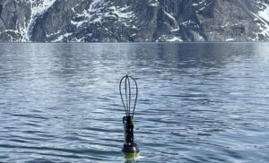
Measurements taken in situ – that is, real instruments taking measurements in the ocean – provide invaluable ground-truths for numerical models and satellite observations. Without real measurements, we have no way to know that our models and satellites are giving us reliable information – particularly in regions where measurements have historically been difficult to obtain.